Ourthe Circuit · Ortho & Bande
45.7 km · loop · sample.gpx
Your recording, read back to you like a co-driver.
You drove something good once and recorded it. Roadbook '71 matches that track to real roads and reads it back to you at the wheel, with every junction drawn as a tulip taken from your own recording. Set off from wherever you happen to be parked and you are back at the join before lunch.
 iPhone · iOS 17+ · free
Not in the store yet. Join the TestFlight beta
iPhone · iOS 17+ · free
Not in the store yet. Join the TestFlight beta
- 0.60+0.60Left onto Route de Hives
- 7.81+7.21Right onto Beaulieu
- 13.01+5.20Right onto Route Saint-Quoilin
- 13.21+0.20Right onto Rue des Ecoles
- 15.97+2.76Sharp right onto Route de la Barrière
- 28.00+12.03Right onto Grand-Rue
- 28.30+0.30Sharp right onto Rue Tahée
- 28.46+0.17Left onto Rue de Haute Tahée
- 29.66+1.20Left onto Route de Lignières
- 33.90+4.24Right onto Rue de La Roche
- 42.01+8.11Right onto Vecpré
- 44.96+2.95Right onto Avenue du Hadja
Twelve real junctions on a September morning in the Ardennes. Every diagram is drawn from the recording itself, the same file you can download at the foot of this page, and none of them came out of an icon set.

What Roadbook '71 is
Roadbook '71 is a free iOS and CarPlay app that turns a recorded GPX track into turn-by-turn navigation, with every junction drawn as a rally-style tulip diagram computed from your own recording. It is built for one job: driving a long recorded loop again without a passenger reading the map out loud.
- Platform
- iPhone, and Apple CarPlay
- Requirements
- iOS 17 or later, and a GPX file
- Price
- Free. No subscription, no in-app purchase, no ads
- Privacy
- Nothing collected; location stays on the device
- Developer
- glue.blue, Belgium
- Version
- 1.0
Your recording is the route
§ 01 · corridor matching

Ask a maps app to take you from Ortho back to Ortho and it has nothing to say. Its job is to get you there, and you are already there. The forty-five kilometres in between, the ones that were the entire point, are not a destination it knows how to want.
Roadbook '71 starts from the other end. The recording is the truth, and the road network is only asked for the words. The app samples waypoints along your track (sparse down a straight, dense through a hairpin, because a corner is exactly where a router will otherwise cut across onto a different road) and chains route requests through them. Every leg that comes back is measured against the recording, and one that strays outside the corridor is retried more densely before it is accepted.
Where no amount of retrying finds a road route that follows your line, the app keeps your line. Guidance goes quiet along that stretch, because it cannot invent instructions for a road the map does not have. So the stretch is drawn in its own colour, measured, listed and announced before you set off: you know where the silence is coming, and you can retry that stretch alone or pin a waypoint to force the route through a particular road.
A recording that jumps 1.8 km with nothing logged in between is a lost signal, not a teleport. That gap gets routed by road rather than drawn as a straight line, and it is marked as a guess. It is worded and drawn differently from a stretch that genuinely goes quiet, because those are different problems and a driver has to be able to tell them apart.

How it works
§ 02 · three steps, in order
Three things happen, and they happen in this order. Only the middle one needs the internet.
-
Import
Open a GPX from the Files app, or send it across from whatever recorded it. Tracks you have opened before are remembered, and they survive a reinstall.

-
Compute, once
Matching a loop to the road network is a few hundred requests. A 100 km loop takes a few minutes, and the answer is cached against the file, so opening the same track again is instant. A build you interrupt picks up where it stopped rather than starting over.

-
Drive
Heading-up map, the next instruction, distance and time remaining, and a voice that only takes the audio session when it actually has something to say, so your music is not ducked for two hours between prompts. Miss a turn and it works out a way back.


Roadbook '71 on CarPlay
§ 03 · the car screen
Hands on the wheel, phone in a pocket, the whole loop on the car's screen. The car screen runs the drive itself: it can start one, follow it and end it without you touching the phone.


Actual CarPlay screens · night appearance. Captured from the app running on a real CarPlay display, not mock-ups and not a phone screenshot dressed up as a car. Both are the night appearance, because the car decides day or night from its own light sensor and the simulator these were taken on has no daylight. In a car at noon the same screens are the day pages.
Both surfaces share one route and one navigation engine, so a drive begun on either shows up on the other. The maneuver panel carries the instruction you are driving towards and the one after it, the distance to the turn, and how much of the loop is left.
The route is drawn on the car's own map, with a stretch where guidance goes quiet drawn unmistakably differently from a bridged GPS dropout. Day and night follow the head unit's own ambient sensor rather than the phone's. A drive in progress is written to disk as it goes, so a backgrounded app that iOS terminates two hours in does not cost you the loop.
Apple grants the CarPlay navigation entitlement by request, per app. Roadbook '71 was granted it on 1 September 2026, so it appears on the CarPlay home screen once the app has been opened on the phone.

Tulip diagrams, drawn from your track
§ 04 · pijlke-bolleke
A tulip is what a rally roadbook prints instead of a sentence, and it is the reason a co-driver can call a junction at speed without looking up. The ball is where you come in, the line is the road through it, the arrow is where you leave, and every other road at that junction is drawn as a stub, because without them the second of three lefts and the only left are the same picture.

Every tulip is turned so the approach runs up the page. That is the whole trick: it means two left turns onto completely different bearings come out looking the same, and a driver holding the book at speed never has to work out which way up it goes.
These six are computed from the eighty-five metres either side of each junction in sample.gpx, using the same window the app uses and fitted into the same square. Your own recording produces its own diagrams, and no two junctions come out identical. There is no icon library behind any of it.
The stubs are the one part a recording cannot supply: a GPX says which way the car went and nothing about what else was there. So the app asks the map what meets each junction (solid for paved, dashed for a track, heavier for the road with priority), and where the map has nothing to say, the tulip falls back to the diagram the recording alone can support. Junction detail © OpenStreetMap contributors.
The whole loop, all twelve junctions, is also here as a two-page roadbook on paper: distances down the left margin, one instruction to a line, and a box to tick as you pass each one.
Every roadbook prints
§ 05 · on paper


Any route can be printed as a paper roadbook: km down the left with the partial under it, the tulip, the instruction, and a box to tick as you pass it. Notes you have added to a junction print in the margin, in red, where a co-driver would have written them, and one marked as a caution also comes up on the driving screen five hundred metres before you reach it.
Page one carries the loop drawn as a survey plate: a kilometre grid, the route cased in ink, arrowheads showing which way round it runs, a scale bar and a north arrow. It is drawn as geometry rather than map tiles, because a screenshot of a map prints as a grey rectangle and the page has to work in a car park with no signal. The village goes on the instruction where it changes (Right onto Beaulieu (Tenneville)), which is what tells you where you are once the odometer has drifted.
That is the honest fallback for a phone that has gone flat two hours from the car, and it is the nicer way to plan a Sunday at the kitchen table. It is also why the entries at the top of this page look the way they do: the page and the print are the same object, set the same way.
An actual export from the app, not a mock-up: page one of the Ourthe Circuit, from the same file every diagram on this site is computed from. The loop was recorded on 14 September 2025, which is the date the footer carries.
A route also leaves the phone whole: the recording, the roads already worked out from it, every note on it and the printed PDF, in one file. Open it on another phone and the roadbook is there, typed up, with no rebuild. Open it anywhere else and it is a plain zip with the GPX and the PDF inside.
Join anywhere, arrive where you joined
§ 06 · loops
A ring has no start, or rather its start is wherever you happened to press record, which is almost never where you are standing when you want to drive it again.
So starting a drive rotates the loop to the point on it nearest you. You set off from here, drive the full circle and arrive back at the join, rather than at somebody's front door in a village forty minutes away. A track that is not a loop aims the first leg at the nearest point on it instead.
Stop for lunch, or for three days. Pull in at the café by the bridge, have the coffee, and pick the drive up an hour later from wherever you happen to be standing. The drive is written to disk as it goes, so it survives the app being closed, and progress is inked onto both the computed route and the raw recording, so you can see at a glance how much of the ring is behind you.
When the drive is done you can export the ride you actually made as a new GPX: the loop as driven rather than the loop as planned.

Day pages and night pages
§ 07 · appearance

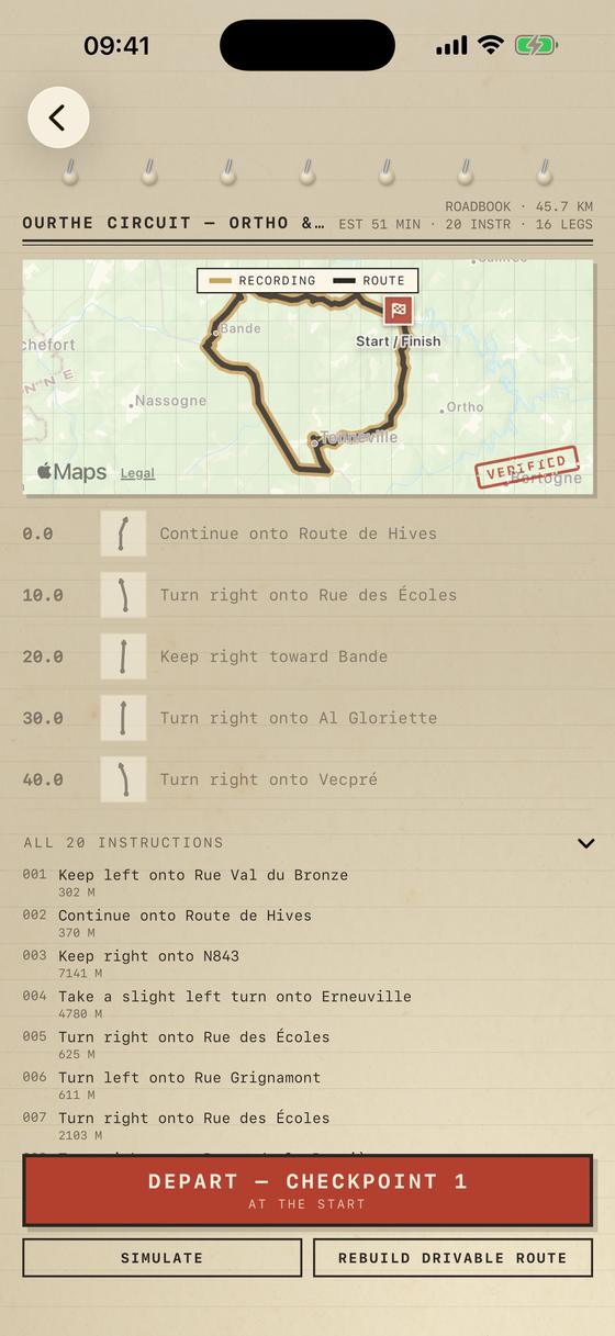
Day pages are paper and ink: aged, slightly green-yellow stock, printing near black, a rubber stamp where a stretch has been signed off as driven.
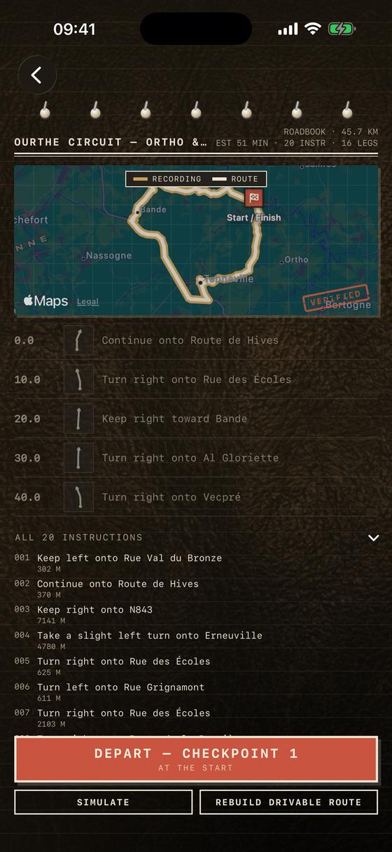
Night is the same book under a map light rather than a grey inversion of the day pages: a near-black cabin, the parchment gone dim and warm, the printing switched to a warm off-white so it still carries. The stamps stay red, because a red stamp under a red map light is exactly what a red stamp looks like.
Paper grain, stamps and margin notes are welcome anywhere except underneath something you read while moving. The maneuver card is clean stock, no grain, maximum contrast. It follows the phone, and in the car it follows the head unit.
Requires an iPhone on iOS 17 or later
§ 08 · requirements

-
An iPhone
iOS 17 or later. CarPlay is there if your car has it; the app works fully without it.
-
A GPX file
Anything that records one will do: Open GPX Tracker, a Strava or Komoot export, a Garmin or Wahoo unit, a route you drew on a map site.
-
A few minutes, once
Computing the route takes a few minutes for a 100 km loop. The result is cached against the file, so you only pay for it once and reopening the track is instant.
-
Nothing else
No account, no sign-in, no subscription. The app is free, and it stays free.
Nothing is collected
§ 09 · privacy
Roadbook '71 has no account, no analytics, no advertising and no server of ours. There is nowhere for your data to go, because there is nothing on the other end to send it to.
- Location is used on the device, to place you on the route and to speak.
- Tracks and computed routes stay in the app's own storage.
- The only network traffic is Apple MapKit, under Apple's privacy policy.
- Deleting the app deletes every bit of it.
Built in Belgium by glue.blue
§ 10 · about

I built Roadbook '71 in Belgium, under glue.blue, for one job: driving a long recorded loop again without a passenger reading the map out loud. It is personal-scale software and it says so: no sync, no sharing, no offline maps, and no route editing beyond a pinned waypoint. It opens a GPX and drives it.
The roadbook styling is doing a job, not just decoration. A roadbook is the one document in motorsport designed to be read at speed by someone being thrown around a cabin, and the things it does (huge distances in the margin, a diagram instead of a sentence, one instruction to a line) are legibility decisions that happen to look good.
There is more of this in the co-driver's notebook: where the tulip notation came from, how to record a track that navigates well, what happens when you hand a routing engine a loop, and a road or two worth going out of your way for.